I really wanted to be in New Zealand. We cancelled the month-long trip last fall. As soon as we can, I’m going, but so far, they’re just not ready to let us scary foreigners in.
So here I am, at a point in my life where I’ll take on a 290 kilometre challenge as a way of filling the time before the Kruger one becomes available.
By the end of today, I will have walked 1,000 km since I started my first Conqueror challenge.
Isn’t that wild?
And so, onwards I trudge. At this point, we can fairly say that I’ve made a habit of walking. Hitting 10,000 steps a day is pretty easy now, instead of a really difficult day. If it’s too rainy or so hot the blacktop is melting, and I can’t bring myself to go out for a walk, I sit inside and fret. The elliptical is exercise, but it doesn’t really scratch the itch of needing to get a certain amount of distance behind me every day. I think the thing that really changed the equation was trying to do 5 kilometres before allowing myself to log in for work. If I could get that big of a chunk of exercise in before becoming glued to a keyboard, there was a higher chance of me heading back out at lunch or right after work. The longer I wait each day to get going, the HARDER it is to get going. I’ve been an early morning person since Ascii, so if I substitute my old two hour commute to work to some time spent on being healthy, I can at least take advantage of the fact that I seem to be operating at a 2-3 hour time difference to the rest of Ontario.
At this rate, I’m going to be able to tackle my marathon in September without an EMT trailing me. 😉
Podcasts
My walks are powered by podcasts. I like to listen to something while moving, so I’ve a roster of podcasts to keep me entertained as I endlessly circle my home. Here are some of the shows that turn up regularly on my playlist. I’m open to suggestions, as I’ve got a thousand kilometres left to walk this year, and eventually I’m going to run dry.
- Listen Up A-Holes: Narrative nerd Lani Diane Rich of Chipperish Media and super hero scholar Joshua Unruh of Pulp Diction Productions apply their wit, expertise and enthusiasm the Marvel Cinematic Universe. This is my absolute favourite, but the hosts are currently on a mostly-break, only resuming when something irresistible from the MCU emerges;
- Buffering the Vampire Slayer: This is a bi-weekly podcast in which your hosts Jenny Owen Youngs (professional musician & recreational Whedonverse aficionado) and Kristin Russo (professional writer & former goth teen) discuss Buffy the Vampire Slayer, one episode at a time;
- Stephen Fry’s 7 Deadly Sins: Take a famous humanist with a voice made to be listened to, and set him loose on a topic. In this case, he explores the 7 deadly sins as defined by Christian scripture in comparison to an independent-minded evaluation of our conduct on the basis of its effects on other people. Do my actions ever hurt others, myself included, I might ask myself, do they hurt those close to me or society or the wider world as a whole
- Stephen Fry’s Great Leap Years – the stories behind inventions: The podcast explores topics ranging from the rise of humankind as the inventor, to the astonishing combination of persistence, investment and inspiration it took to create the Gutenberg Press and the communication technologies that created our world. It tells the story of how our lives have been transformed by a fascinating and compelling mixture of human decision and vision, greed and need.
- How Story Works: a podcast for everyone who loves stories. If you’re a writer, understanding how story works will help you craft better stories. If you’re a lover of stories, the podcast will give you added insight into your favorite tales, and extend the toolset you use to better understand the stories you love. Join NYT bestselling author and story expert Lani Diane Rich as she demystifies stories and storytelling, allowing you to better write and appreciate the stories you love.
Postcards
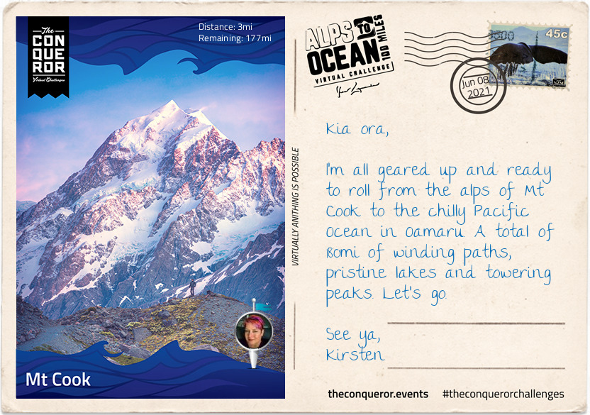
Imagine crisp alpine air, snow-capped peaks, glaciers, milky lakes and starlit nights. The training ground for Sir Edmund Hillary’s climbing skills in preparation for Everest. The legendary story of Aoraki and his three brothers. These are just some of the highlights of Mount Cook.
At 12,217ft (3,724m) tall Mount Cook is located on the South Island and the tallest mountain in New Zealand. It sits within the Mount Cook National Park which runs 37mi (60km) in a southwest-northeast direction. Home to more than 400 flora and fauna the national park is part of the Te Wāhipounamu South Westland World Heritage Site. The park is also home to 35 species of birds, including the only alpine parrot called Kea.
When I was looking into Mount Cook, I was wondering about the 98ft (30m) height discrepancy between different written sources. Further investigations revealed that in 1991 an avalanche of 350 million cubic feet (10Mm³) of snow and rock followed by twenty years of erosion had shrunk the mountain’s elevation by 98ft (30m).
Of the twelve largest glaciers in New Zealand, eight of them are within the park with Tasman Glacier being the longest at 15mi (24km). The glacier terminates in the Tasman Lake which up until the 1990s never existed. The lake was formed due rapid glacial melting whilst the glacier itself continues to recede annually by as much as 2,697ft (822m). It is anticipated that within a few decades the glacier will be completely gone and the lake fully formed.
The lake’s primary outflow is the alpine braided Tasman River which flows south for 16mi (25km) through the Tasman Valley and into Lake Pukaki. The glacier, lake and river were named after Dutch explorer Abel Tasman, who in 1642 was the first European to sight the northwest coast of NZ’s South Island.
My journey begins at the base of Mount Cook, northwest of the river. Needing to cross the river to connect to Rotten Tommy trail, I took a short helicopter flight. The aerial view of this glacially-fed river and Mount Cook was a sight to behold. From Rotten Tommy, I took a southward bound route alongside the Tasman River. Although part of the route was quite rough and I had to cross several creeks, eventually the track changed to gravel road and made it easier to navigate towards my first overnight stop. Being a clear and sunny day, I had the treat of seeing Mount Cook in the distance rising above the lower snow-capped peaks in the National Park.
Before I go let me tell you about the Ngāi Tahu legend. The story goes that once the “Gods existed in the midst of a great sea of nothingness” and Raki, the Sky Father and Pokoharua-te-po, his wife had four sons, all living in the heavens. Raki left his wife to be with Papatuanuku, the Earth Mother, and together they created the world. Aoraki, the eldest son of Raki, along with his three brothers came from the heavens with a canoe in an attempt to persuade their father to return to their mother. Upon seeing him together with his new wife, the brothers knew Raki would never return. The brothers decided to go home but unfortunately their canoe wouldn’t rise and following strong winds and rising seas, the canoe overturned tipping the brothers into the water. Climbing atop the upturned canoe they waited for help. As time passed with no help coming, they eventually turned to stone. The canoe became the Southern Island and the brothers became the Southern Alps with Aoraki (Mount Cook) being the highest peak.
Cheers
Kirsten
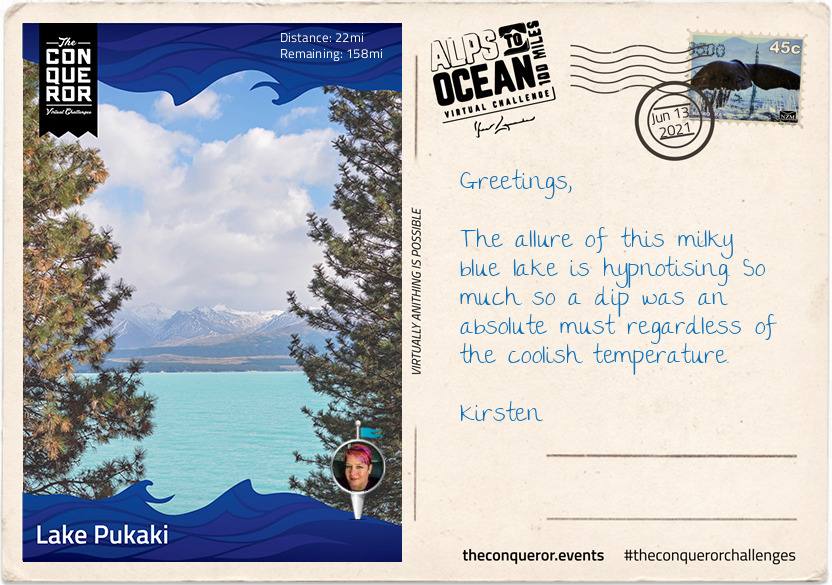
My lodging on Lake Pukaki was under the star-studded sky of the southern hemisphere. Here the Southern Cross, Milky Way and the inverted view of the Orion constellation are just part of the night sky spectacle. Lake Pukaki sits in the Mackenzie region, one of very few regions around the world classified as an International Dark Sky Reserve. Due to its limited light pollution, the night sky with millions of stars are visible as far as the eyes can see.
Lake Pukaki is the largest of three parallel alpine lakes in the Mackenzie Basin with Lake Tekapo and Lake Ohau being the other two. It’s milky blue colour is a result of finely ground rock particles from glaciers. The lake is part of the Waitaki hydroelectric scheme providing hydroelectricity, irrigation and municipal water supply. The lake originally had an outflow at the southern end but it has since been dammed. To increase storage capacity the lake has been raised twice eventually submerging Te Kohai Island which appeared on NZ’s five pound note pre-decimal currency era. Looking at some of the old images of Lake Pukaki there was a time in the mid-19th century when ferries were used to cross the river outlet south of the lake with a hotel on the bank. A bridge was added in the late 1800s. Both the bridge and hotel have now perished with the raising of the lake.
Firing up for today’s longer journey, I indulged in a sizeable breakfast, a quick swim in the lake to get the blood circulating and I was ready to tackle the next stage. I continued the trail on the eastern side of the lake on a nice quiet country road. Travelling along the shoreline of the lake I was greeted with incredible northward views of the Southern Alps and Mount Cook and kept imagining them as the mythical Aoraki and his three brothers. Directly across the length of the lake was the Ben Ohau range known for its ski touring route across the top of it.
Carrying on the trail I crossed the Pukaki Dam towards the Salmon Shop at Lake Pukaki Visitor Centre. It all went rather well until I reached the southern section of the lake and found myself exposed to the gusty winds from the north-west. It was quite the balancing act aiming to move forwards without taking a tumble down the cliffs and drop-offs near the trail.
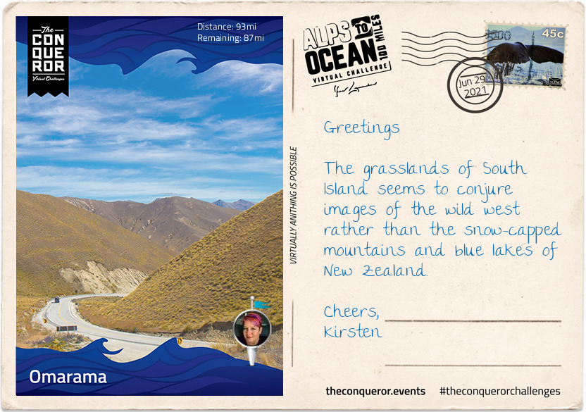
With a stop at the Salmon Shop for some locally farmed freshwater salmon, I took this opportunity to gather my rattled nerves, have a rest and absorb the last of this vista. I left the lake behind and moved on south across the Pukaki Flats, a substantial expanse of tussock grasslands and a very flat route. These dry grassy plains are distinctive to the South Island and are largely used for grazing livestock. Without any shading available, plenty of water was necessary and a good head covering.
Having made it into the region’s largest town with time to spare, I’m off to see the highlights before I turn in for the night. I’ll tell you all about it in my next letter.
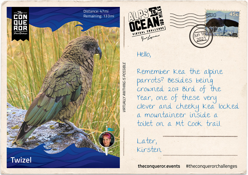
I enjoyed some exploring in Twizel. It’s the largest town in the region which unsurprisingly triples in population during the summer period.
The town is relatively young having been founded in 1968 to house construction workers on the hydro scheme. Clever town planning placed all the services and schools in the centre with housing surrounding the central hub. Pedestrian paths straight into the centre made it more direct for residents to walk instead of driving the looped roads to get to the same destination. When the scheme wound up 15 years later the local residents successfully fought to save their town.
To the south of town is Lake Ruataniwha, an artificial lake formed in the late 1970s as part of the Hydro scheme. The lake is fed by Ohau River to the west and the overflow discharged from Lake Ohau further west. At 3mi (4.5km) long the lake is open to water enthusiasts with activities such as sailing, water skiing and rowing. I chose to stand-up paddle board but those mountainous views and blue lake were spellbinding. I should’ve just sat on a boat and soaked up the landscape.
Since I was already dressed for water activities I ducked across the State Highway to a waterhole I wanted to swim in. As blue as Lake Pukaki was this ‘no name’ waterhole was emerald green greatly emphasised by the reflection of the willow trees on the waterhole’s edge. There was a time when the swimming hole was part of the Ohau River before the nearby dam and artificial lake disrupted the river’s flow and greatly reduced its size in the east separating the swimming hole from what is left of the river. If you have a satellite view of the waterhole it looks like a big emerald green bath.
Back in the late 1800s when Ohau River had its natural flow, crossing it was done by wire rope and a cage. In 1890 they built, what is now referred to as, the Old Iron Bridge. It served travellers for the next 80 years until the Hydro scheme came into the area, built Lake Ruataniwha, realigned the State Highway and bypassed the iron bridge. The bridge is now listed on NZ Historic Places Trust. A small monument can be found near the lake in memory of a mother and child who drowned in 1879 whilst fording, illustrating the difficulties and dangers of crossing the Ohau River at the time.
There’s another swimming hole called, Loch Cameron, northwest of Twizel, worthy of a visit but if I hoped to get to my next destination sometime today, I had to get cracking with my journey.
Making my way out of Twizel via the southern edge of Lake Ruataniwha, I followed the trail along the west side of Ohau River to Ohau weir. The weir is a low head dam that was constructed with a siphon to maintain a minimum flow into the Ohau River but conversely may overflow restricting access to travellers. Not needing to concern myself with flooding, I enjoyed my travel along the shore of Lake Ohau reaching the village for some lakeside dining and background view of Ben Ohau range.
Here I am at Lake Ohau, the third and smallest parallel glacial lake in the Mackenzie Basin that serves as a water storage for the Hydro scheme. It is connected to Lake Pukaki and Lake Tekapo (the other two parallel lakes) via an artificial canal. Lake Ohau is stunningly located between The Barrier mountain range to the west, Ben Ohau range to the east and Naumann range to the north which lies between Hopkins and Dobson rivers that feed into the lake.
This turquoise blue lake is a perfect environment for both powered and non-powered activities. Although at the height of summer the temperature reaches a mere 60°F (15°C) any swimming enthusiast wouldn’t want to miss the opportunity for a crisp splash in the lake. Luckily for me the weather was in my favour and I went for a brisk swim before starting my onward journey. However, I did hear that any sailor or windsurfer on the lake must be mindful of the northerly winds as the water gets choppy very quickly.
It might be debatable what’s considered a national dish in NZ, perhaps fish and chips or perhaps a gourmet meat pie. No matter, my choice was the traditional piping hot meat pie encased in a crispy pastry. This humble meat pie has been part of NZ’s cuisine since 1863 when the early British settlers brought it to NZ’s shores. It’s the perfect size to be eaten with one hand whilst chugging their popular Lemon & Paeroa soft drink with the other. The soft drink’s history goes way back to 1907 when it was originally manufactured in the town of Paeroa by combining lemon juice and carbonated mineral water.
After my finger-licking good pie and L&P hydration, I set off for what was to be the hardest part of the journey. The first 3.5mi (6km) was an easy section as I traversed the lower slopes of the Ohau range across several creeks before I found myself on a narrow track and a sustained climb of about 2.5mi (4km) to the highest point of the trail at 2,952ft (900m). Not that I particularly trusted that I was at the highest point for a while since all along there were several “false summits” where the trail appeared to reach the highest point to then discover that there was more upwards winding to go. During the winter months part of this upward climb proves to be even more hazardous as it becomes part of an avalanche path.
Reaching the top was quite the accomplishment but given its exposure and strong winds I spent little time admiring the view and started my descent. If I thought the climb was a challenge the steep descent with its tight steep bends was even more ghastly for the next half-mile or so.
The rest was a rolling descent crossing several streams. Clean drinking water could be collected at these streams enabling me to top up my bottles. The track joined with Quailburn Road and for the remainder of my journey I travelled beside Quail Burn River first to the west of me and once I crossed it to the east of me, almost like a constant companion, until we parted way with the river flowing into Ahuriri River and me rolling into Omarama for the night.
Having left the alps and peaks behind, the town of Omarama marked the halfway point of my journey. Although a small rural town, mainly a service centre for locals and nearby residents, Omarama had a few surprises up its sleeve.
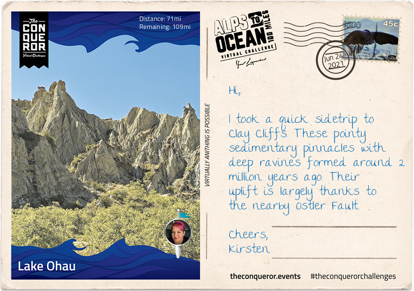
Disney’s 2020 movie release of Mulan was entirely shot in New Zealand with scenes filmed at the Clay Cliffs just outside of Omarama.
In 2009, NZ pilot Terry Delore set a new world record in his 87ft (26.5m) wingspan glider. Taking off from Omarama, Terry travelled 1,491mi (2,400km) up and down NZ for 15 hours reaching speeds of up to 93mph (160kph) before landing back in town. Omarama has strong gliding conditions making it a popular destination for gliding pilots. Omarama hosted the 1995 and 2007 World Gliding Championships of which Kiwis took first place in the 1995 open category and third place in 2007.
For the weary soul like myself a Hot Tub soak the night before to rejuvenate my muscles and unwind was just what I needed. The Hot Tub was located outside in a private setting within a tussock and rock landscape. The tub was filled with fresh mountain water without any chemicals added. The business reuses the water for irrigation. A submersible firebox allowed me to adjust the water’s temperature. As I settled in, I watched the Milky Way appear and spill across the night sky with its millions of stars.
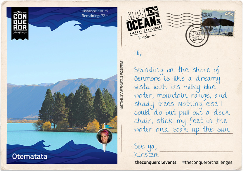
Eastward bound, I left Omarama refreshed and ready to tackle the next half of the journey. The trip was relatively easy and short when compared to previous days. The first half of the trail was off-road running parallel to the State Highway on the right. Crossing at Chain Hills to the left of the highway I began my descent alongside Lake Benmore, the largest artificial lake in NZ.
Lake Benmore was created in the 1960s as part of the Benmore Dam construction. The lake is split into two arms. The largest is fed by three rivers, Tekapo, Pukaki and Twizel plus the Ohau canal with Waitaki River flowing right through the lake, whereas the smaller arm is fed by Ahuriri River.
It is this smaller arm that I travelled along to Pumpkin Point, a grassy beach area, for a break and a splash in the lake, then onto Sailors Cutting where the off-road trail terminates and I join the highway for the rest of today’s trip. Not the most relaxing part of the journey as I braved the high-speed highway with an upward climb to Otematata Saddle. The views of Lake Aviemore and the valley beyond was a lovely compensation until I continued on the busy highway downhill all the way into Otematata.
Defined as “a populated area less than a town”, Otematata is more of a holiday town nowadays when it’s small population of around 180 explodes to 5,000 during the summer season. With easy access to both Lake Benmore, downstream Lake Aviemore and nearby hiking trails (known as tramping in NZ), holiday makers swarm to the area for camping, water skiing, boating, fishing, swimming and cycling among other activities.
Otematata sprung up in 1958 as a base for construction workers of the Benmore and Aviemore Dams. Within a year the population grew to 450 and at its peak it was as high as 4,000 residents. Built by the Ministry of Works the town had all the necessary facilities and services such as schools, clubs, pub, cinema and mall. The 1,500 strong workforce of engineers, builders, electricians, concreters and truckies spent seven years building the dam. Once the dam was finished, as it often happens with these kind of projects, the town was slowly dismantled. The houses that were trucked into town were years later trucked out and moved to Twizel for the next project. Benmore Dam is the largest earth-filled dam in NZ and the largest of eight in the Waitaki hydro scheme. As the second largest hydro station in the country, Benmore generates sufficient electricity to cover nearly 300,000 NZ homes.
Leaving Otematata, I travelled north on a sealed pathway alongside the Waitaki River until I reached the massive Benmore Dam and stood atop it with a bird’s eye view of the lake to the north and the river to the south. When the lake is over capacity, the floodgates open to release the water down a spillway and to prevent erosion a lip was inserted at the end to deflect the water. The spillway can handle ten times the normal river flow thereby allowing it to cope with severe flooding.
I skirted around the shore on a narrow sealed road to Deep Stream Track on Lake Aviemore for a walk along a flooded canyon. The deep green water was quite inviting for a swim but I settled for a picnic under a shaded tree enjoying the tranquility of this location and the reflection of the hills on the water.
A little further I crossed the Aviemore Dam back onto the State Highway and was relieved to be travelling on an off-road path beside the main road all the way to Waitaki Dam. Aviemore Dam was built in 1968 and the construction was on uneven ground because the Waitangi Fault runs beneath it. Although at the time of construction the fault was considered inactive, in the 2000s the fault was upgraded to dormant and as such the dam was reinforced against earthquakes and potential landslides. Because of the fault the dam is a mixed structure being part solid rock topped with concrete on the north side and earth-fill where the fault line runs beneath on the south side.
The Waitaki Dam is steeped in NZ history. As the smallest in the Waitaki hydro scheme, it is also the oldest having been built in 1935. Being the first dam to be built on the South Island, it was also the last to use pick and shovel. These archaic tools were retained because politicians wanted to reduce the unemployment rate during the Depression Era.
The building of the Waitaki Dam inadvertently played a major role in the birth of the social welfare system. In 1928, the Waitaki Hydro Medical Association together with the Waitaki Hospital Board developed a scheme to deduct monthly fees from wages in order to provide medical and ambulance services to the workers. When two politicians, one a doctor and the other a reverend, took office in 1935, they based the social welfare scheme on the one developed by the dam project.
From here it was a 5mi (8km) journey into Kurow. I heard the Waitaki Valley, which begins in Omarama, is a young winery region with a flair for developing good pinot noir and pinot gris. I’ll be sure to sample some after a hearty meal. I’m thinking fish and chips at the nearest pub.
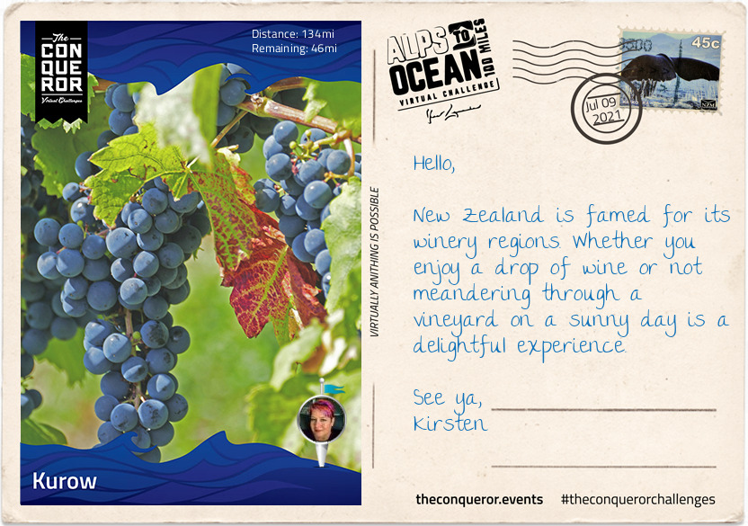
Summer fruit orchards and wineries seem to be the economic backbone of Kurow, a small town that in the 1920s was the base for the construction of the Waitaki Dam.
Kurow sits within the Waitaki Valley, a rich limestone region with a cool maritime climate. With warm summers and long, dry autumns this region is a wonderful environment to grow grapes for wines such as pinots noir and pinot gris. The first vines were only planted in 2001, making this valley a very young winery region. I can imagine it took passionate and dedicated viticulturists to have the courage to explore new grounds and experiment with different plantings. Small scale, family-run vineyards are now dotted through the valley creating bespoke, boutique wines.
Just outside of Kurow is a family-run orchard growing summer fruits such as peaches, apricots and cherries. Conscious about fruit that is rejected by supermarkets due to imperfections, the family built a commercial kitchen and went about turning rejected fruit into a range of products such as jams, sorbets and baked goods. With a half dozen box of summerfruit tarts under my arms, I was ready to leave Kurow.
Joining the trail alongside the Waitaki River, I marvelled at its characteristics. This 68mi (110km) braided river begins at the confluence of Pukaki, Tekapo and Ohau Rivers with Lake Benmore atop it. The river acts like a link between the lower lakes by running through and connecting Lake Benmore to Lake Aviemore to Lake Waitaki before it freely and swiftly flows the rest of the way into the Pacific Ocean.
Between Kurow and Duntroon, I had to ford three rivers and I was grateful they were not flooded permitting me to travel beside Waitaki River and admire the mountain range behind it, instead of using a trail next to the highway. I’m also glad I read the instructions to not touch the fences along the way as many are electrically charged and not necessarily marked for information. Might’ve added an element of excitement I wasn’t really looking for.
Just before reaching Duntroon, I stopped at the Takiroa Rock Art Shelter to see the Maori art on the limestone rock that dates back to between 1400 and 1900AD. After the rock art site, I carried on through Duntroon’s Wetlands into Duntroon straight to the local pub for a feed and more Waitaki Valley wine sampling.
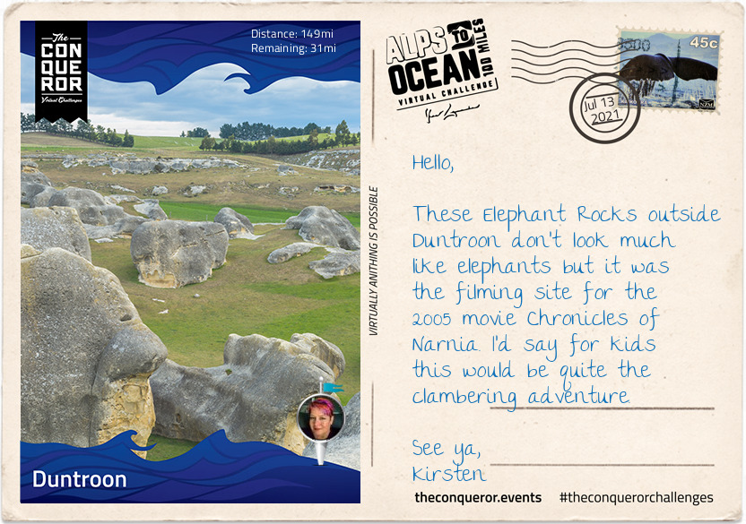
The small farming-town of Duntroon is home to around 120 residents. It’s main economy is largely sheep farming and crop growing such as wheat and barley.
The town was bestowed its name by one of a handful of Robert Campbells that emigrated from the United Kingdom to Australia and New Zealand. It took quite a bit of unravelling and genealogical construction to discover which of the four generations of Robert Campbells was the relevant one associated with Duntroon. It seems that the name Robert was greatly favoured in the family.
The first Robert (#1) was a grand-uncle from Scotland who was the first merchant in the 1788 British colony New South Wales (Australia) and later a politician. Having built a private wharf at the time he is now referred to as “Campbell of the Wharf”. He had a son named Robert but his brother, John, also had a son named Robert (#2).
This nephew, Robert (#2), arrived in Sydney in 1806 and by 1818 he was the Director and afterwards the President of the first formal bank in Sydney, the Bank of NSW, today known as Westpac. Having also built himself a mercantile business on Bligh Street, Sydney, he became known as “Campbell of Bligh Street”. This Robert, unsurprisingly had a son also called Robert (#3), who was born in Sydney but chose to return to England and became a Member of Parliament from which he was unfortunately unseated threes month later. To distinguish him from previous Roberts’ he was given the appellation “Robert Campbell Tertius” meaning the third.
Finally the relevant Robert (#4), son of Robert Campbell Tertius, who was born in England in 1843, travelled to New Zealand early 1860s to either buy or lease land on behalf of the family. Robert became a successful sheep farmer, property owner and later politician. Together with his father, he owned a sheep station in the Waitaki District upon which they built a small town they named, Duntroon, a Scottish name possibly as homage to their ancestry and their ties to Clan Campbell of Argyll, Scotland.
Robert’s (#4) wife, Emma, bequeathed £6,000 to the parochial district with instructions to build a church for the benefits of Church of England members. The result was St Martin’s Anglican Church in a 14th century Gothic style, built out of limestone quarried in a nearby region. The side church door bears the Clan Campbell coat of arms. Sadly both Robert and Emma died childless and within a few months of each other.
By 1875 much of the acquired Campbell lands became plagued by rabbits that were imported in the 1830s and released for sport. Unable to curtail their rapid reproduction rate, by the early 1880s the pastures were depleted and hillsides eroded. This in turn produced lower quality wool thereby affecting the prices of wool. In the end, the devastation wrought in the region forced many sheep station owners into bankruptcy and the Campbell’s businesses in NZ were eventually wound up and ceased operating by 1920.
Just off the main highway is the Vanished World Heritage Centre, a fossil and geology museum that includes the fossils of two species of extinct genus of large penguins from around 27-28MYA. Known as Archaeospheniscus, the species is about the size of an Emperor Penguin. There was a third species, albeit a smaller one, in this genus that was discovered in Antarctica. These three species are the only ones currently existent in this genus.
Having left Duntroon, I’ve parted ways from Waitaki River which has been my companion since the Waitaki Dam and moved in a south-east zig-zag direction until I stopped at the Rakis Railway Tunnel, an old disused railway line. During the 1880s depression era the construction of the railway provided much needed unemployment relief. The 11mi (19km) line was in use from 1887 to 1930. Today the tunnel is only 330ft (100m) long and although it can be explored, a torch is needed because halfway in the tunnel curves cutting out all source of natural light.
Today will be by far my longest route of this entire journey, hence writing this letter on one of my rest stops. I look forward to rolling into my final destination, Oamaru.
Finally here I am 180mi (290km) later, having travelled from the alps of Mount Cook, along multiple lakes, countless connecting rivers, past seven Waitaki Hydro power stations, various mountain ranges, through tussock grasslands, beside electric fences (do not touch) to arrive in the urban town of Oamaru on the shore of the Pacific Ocean.
Oamaru is the largest town in the region and renowned for its Victorian precinct. A commercial streetscape, the Neoclassical architecture is a result of Scottish architect and engineer, Thomas Forrester, who emigrated with his family to NZ in 1861. Arriving in Oamaru to supervise the construction of the Bank of Otago, Forrester stayed on and shortly afterwards was integral to the construction of the Oamaru Harbour. Taking samples from the harbour floor, he deduced that the seabed could be dredged permitting the development of a deep water anchorage. This in turn allowed large ocean-going vessels to safely steer in and out of the harbour. Forrester then changed direction and together with his business partner, over a period of three decades, designed and built the various commercial buildings that still stand today. The precinct bustles with cafes, antiquity shops, bookshops and galleries. Each year it conducts the Victoria Fete, a one day fundraising event with stalls, music, food and period costumes. The funds raised go towards the ongoing care and restoration of the Victorian buildings.
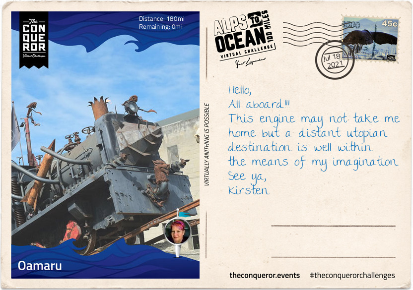
For steampunk enthusiasts, inside one of the Victorian buildings is Steampunk HQ showcasing a collection of quirky items in retro-futuristic sci-fi style whilst outside is a full size train engine spitting fire and billowing smoke. Promoting sustainability and recycling Steampunk HQ collaborates with like-minded artists on projects to continue expanding the collection. Wish you could join me for a steampunk-Victorian era inspired dress-up and for a time feel like we have been transported into an alternative 19th century England.
At the north end of the Victorian precinct is the oldest public garden in NZ. When the town was surveyed in 1858 an area of 34 acres was set aside as a public reserve. Eighteen years later in 1876, the Oamaru Botanical Gardens was opened. Besides the flower beddings, bushes and trees the garden is dotted with various attractions such as the Japanese red bridge, Oriental garden, croquet lawn, sundial, aviary, peacock house, an Italian marble fountain and the Wonderland Statue made by the famous Scottish sculptor Thomas J Clapperton which he donated to the children of Oamaru in 1926. Thomas also made the bronze soldier sculpture on the World War 1 Memorial in Oamaru and is famous for his Robert the Bruce sculpture adorning the entrance of Edinburgh Castle, Scotland.
As I stand on the end of the pier and look across the expanse and vastness of the Pacific Ocean, I wonder at its hidden stories, sunken ships and deep trenches. I wonder what Portuguese explorer, Ferdinand Magellan was thinking when in 1521 he sailed across the Strait of Magellan into the Pacific Ocean and was inspired to name it Mar Pacifico which translates as Peaceful Sea. It’s certainly questionable when you consider the heavy swells, the earthquakes, volcanoes and tsunamis that have battered many Pacific islands and sometimes obliterated complete towns. When I consider the depth and perpetual darkness of the Mariana Trench or the Pacific Rim with the highly active Ring of Fire, peaceful is not something that comes to mind but it is intriguing and fascinating.