
My original plan was to do the Kruger Park challenge next, but they’re in the middle of fixing the street view (no animals in sight the whole way!) and length to make it a bit shorter. So, while that challenge is out of commission, I’m tackling Mount Kilimanjaro instead. At only 97 kilometres, I could finish this one quickly (’cause I need more medals for the collection) before taking on the much longer Alps to Ocean challenge at 289 kilometres… and by then Kruger Park should be fixed and ready to enrol. It’s a bit weird… I am now trying to calculate distances as time to line up a challenge start date to me finishing one. As hobbies go, at least this one is healthy!
I have logged more than 700 kilometres since I started this addiction. On the week I signed up for the first challenge, I hadn’t actually left my condo in days. Now I am out-of-sorts if I can’t get in two walks a day.
When the world opens back up again and I get back to travelling, I am going to be much better positioned to really enjoy myself.
For the record, I love the end of the last postcard this challenge sent me:
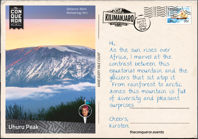
In Swahili, Uhuru means Freedom. Here at the top of Africa, I felt free and unconstrained, just like this tall free-standing mountain called Kilimanjaro.

Tanzania 2012
I did go to Tanzania back in 2012 on my very first safari. The good folks over at Socially Responsible Safaris made sure we had an incredible time that we will never forget. Michael and I now have a lasting addiction that makes us want to return to the African continent every two years. We’d go every year, but there is a whole globe to explore, so we need to divide our time wisely!
Our first safari taught us so much:
- The people are wonderful. We met so many incredible folks as we travelled… each of whom spoke at least two languages, usually three or more. They were warm, friendly, and deeply knowledgeable;
- Temperatures can vary quite a bit from day to night. You will actually get to use the light jacket they asked you to pack at night, and drink more water than a camel could hold at noon;
- When you camp in the national park, you are not visiting the zoo, you are inside the zoo. After the first night of being woken by a hyaena snuffling at the tent flaps and being shooed away by a Masai warrior, your perceptions of boundaries are sharply re-adjusted;
- Drivers are incredibly tolerant souls. On day one, they let us stop the vehicle for 10 minutes to stare at a warthog 300 feet away from the vehicle on the way from the airport to the first national park we visited. We had no idea that we would be within arm’s length of the most incredible creatures every single day. They smiled at us indulgently and let us carry on like we’d made the find of the century without ever once hinting what was yet to come;
- When making requests about what you would like to see, be specific. Ryan asked what I’d like to see next, and I said “Giraffe!”, so they sent a call out over the radio, and whisked us to to another waterhole so I could observe a pride of lions with bulging bellies sleeping next to a dead giraffe, sprawling with their legs in the air like a macabre post-Thanksgiving dinner scene. Point taken: I should have said, “I would like to see a live giraffe, being super cute and gangly, please”;
- Impala are the McDonald’s of the Serengeti. They have an M stamped on their butts, there is one on every corner, and everybody eats them;
- Any day that doesn’t begin with a drive out into the field at the break of dawn is probably a day spent earning enough to come back to Africa.
You can see some of the photos from that trip in our Google photo album.

Postcards
Mount Kilimanjaro, Kili for short, is located in north-eastern Tanzania and it is the largest free-standing mountain in the world. It has three volcanic cones: Kibo (dormant), Mawenzi and Shira (both extinct). It stands at 19,341ft (5,895m) above sea level and is one of the 7 Summits in the world. Kili is within the Kilimanjaro National Park, a UNESCO Heritage Listed site since 1987.
The first successful summit of Uhuru Peak was made in 1889 by German geographer, Hans Meyer and Austrian mountaineer, Ludwig Purtscheller. It was Meyer’s third attempt to summit and Purtscheller had the privilege of celebrating his 40th birthday on the summit. It took another 20 years before someone else summitted again.
It took the better part of the 20th century before Kili became a trekking destination. In 1939 only 58 people visited and less than 1,000 visitors by the 1950s. Fast forward to the mid-1990s and it exploded to 11,000 trekkers and by the 21st century Kili sees an average of 35,000 climbers per year.
There are five climatic zones on Kili:
- Cultivation [4000-6000ft / 1200-1800m] – a highly productive agricultural terrain due to the fertile volcanic soil. Small nocturnal mammals such as tree hyrax and galago reside here.
- Forest [6000-9200ft / 1800-2800m] – a lush and dense ecosystem with high rainfall. Squirrels, antelopes, monkeys and leopard roam the area.
- Heather and Moorland [9200-13,100ft / 2800-4000m] – the heather ecosystem connects the wet forest below with the arid moorland above. Due to lack of foliage the moorland is dry, cold and windy with overnight frost. Elands a type of antelope occupy this area.
- Alpine desert [13,100-16,000ft / 4000-4900m] – this zone consists of almost no vegetation as it is cold and dry but with lots of sun. Temperatures fluctuate and water is scarce. Hardly any animals venture here except for the occasional African wild dog.
- Arctic [16,000ft / 4900m and above] – below freezing temperatures at night with very little rain, plants or animals.
There are seven established routes on each cardinal point. The most popular being Machame and Marangu both from the southside of the mountain. Wanting to experience a more remote and quiet route, I opted for the Lemosho Route from the westside with a plan to swing left onto the Northern Circuit circumnavigating Kibo to Barranco Wall on the southside and wind up to the summit, Uhuru Peak. Lemosho is a relatively new trail, added by the National Park to reduce congestion on other routes.
Another reason for choosing Lemosho is that it is longer with shorter elevation gains thereby making it a slower and more natural acclimatisation experience. Camping all the way through, the route is a repeated “climb high, sleep low” which provides ample time to adjust to a higher altitude. Acclimatisation is an important part of the trek. My body is used to working at sea level where oxygen intake is at maximum. However, once I climb beyond 6561ft (2000m) the air thins out and I need time to adapt to less oxygen. The further up I go the more adaptation I need. By disregarding gradual adaptation, I could end up with Altitude Mountain Sickness (AMS) that could develop into pulmonary oedema or cerebral oedema which could prove fatal. Certainly if I was to show signs of AMS the best way to manage it would be by descending, taking AMS medication and/or resting an extra day as my body recovers and adapts.
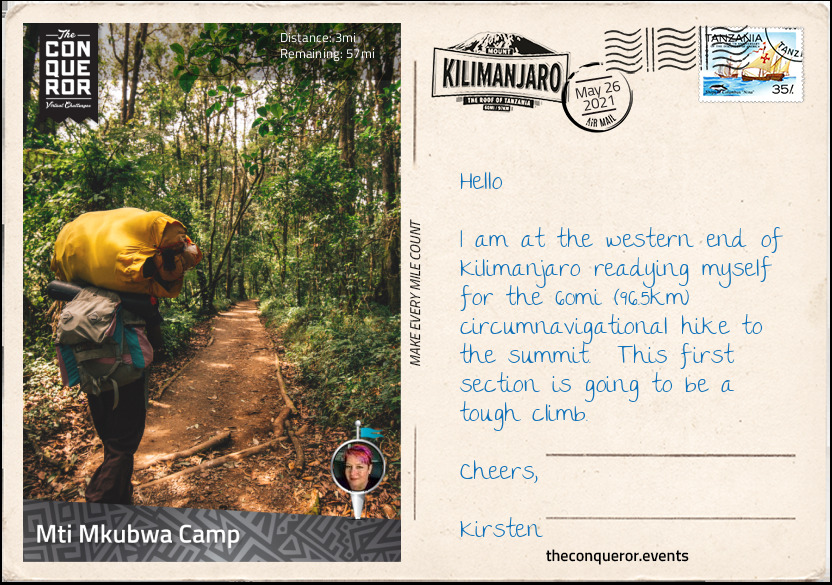
The route begins at Lemosho Glades at 7380ft (2100m) above sea level. Standing at the Lemosho Gate I was surrounded by a dense rainforest very clearly indicating what I would be experiencing on the first stage of my climb. The path was narrow but very well maintained. Either side was a green wall of deep foliage with light filtering through the canopy.
With Kili only three degrees south of the equator, it means that the temperature does not fluctuate much, and the forest is quite humid especially after heavy rain. This is a great environment for plants to grow and thrive. Ferns, junipers, sycamore trees and moss are just some of the plants found in the forest zone along with the endemic ‘Impatiens Kilimanjari’. This flowering plant is only found in the jungle floor of Kilimanjaro. The inch-long flower is pinkish-red that’s a little orchid-like but it has a yellow tail that from a profile looks more like a tropical seahorse. As a perennial plant it blooms almost all year round.
Anyway this wondrous undisturbed forest was a constant visual delight as I ascended the trail at a steady pace up to Mti Mkubwa Camp. The trail itself didn’t deviate, it continued to be mostly narrow and well maintained, hiking single file. The camp’s elevation was 9120ft (2780m). It was nestled amongst tall trees with the tents setup ready to be occupied and the mess tent prepped and ready for dinner. After 4+ hours of trekking I was famished and looked forward to a hot stew, crunchy bread and a cuppa to replenish my burnt calories and fully fuel me for the next stage.
As I continued on with the hike through the forest the trail gradually steepened crossing several streams. Rounding the northern slope of the Shira Ridge at 3937ft (3600m), I emerged from the rainforest onto the expansive Shira Plateau descending 328ft (100m). The pace has slowed to help with acclimatisation.
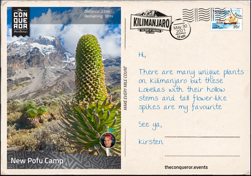
The Shira Plateau stretches over 8mi (13km) at an elevation of 12,998ft (3962m). It was originally one of the three volcanic cones and the first volcano to die out. About half a million years ago, Shira collapsed in upon itself creating a caldera. When the Kibo cone exploded 360,000 years ago for the last time, the lava and debris filled the Shira caldera turning it into the plateau it is today. Dark lava rock was visible as I hiked my way across it.
A heather and moorland zone, the plateau was filled with grasses, wild flowers and the unusual looking ‘Dendrosenecio kilimanjari’ a giant flowering plant from the sunflower family. Another beautiful and endemic plant to Tanzania found on the plateau was the ‘Lobelia deckenii”. Growing for several decades with multiple rosettes, the Lobelia produces one large inflorescence and hundreds of thousands of seeds, then dies. Due to the multiple rosettes the plant continues to reproduce and flower repeatedly.
Making my way over the plateau, I crossed more streams and large boulders whilst Kibo majestically loomed in the distance awaiting my arrival.
Reaching the intersection of Lemosho Route and the Northern Circuit, I swung a left turn and commenced my circumnavigational trek around the top quarter of Kili heading north. The terrain is quite arid with very low and desert-like vegetation slowly moving towards the alpine desert zone.
The elevation ascends and descends approximately 656ft (200m) hovering between 13,779-14,435ft (4200-4400m) for most of this northern route. Being the newest trail it was very quiet indeed.
Reaching New Pofu Camp late afternoon, I settled into my tent awaiting another feast to fill my belly and refuel. Looking forward to another soup, a casserole this time and finishing with a nice hot cuppa. From here I had magnificent views into Kenya’s wild lands to the north.
Leaving New Pofu Camp, the trail led me to the Upper 3rd Caves Camp where it intersected with several other trails such as the Rongai, Kibo Hut and School Hut Trails.
The camp was in a somewhat desolate grey-looking environment devoid of colour with only some shrubs and tufts of small grasses. Although it could’ve been perceived as aesthetically displeasing this alpine desert environment was still fascinating to experience with its raw and barren wide open space. If the terrain was rusty red you’d almost think you were on Mars.
With Mawenzi Tarn Camp as my next destination, the most direct route would have been to take the Rongai Trail. With this approach I would remain at the same elevation since I began the Northern Circuit and descended into Mawenzi Tarn Camp at the end. However, I chose to take a lower route by first descending approximately 1640ft (500m) and swung my way around the eastern side of the mountain to Kikelawa Camp and the Kikelawa Caves. The camp is located in a large meadow of tussock grasses and giant dendrosenecio plants. White-necked ravens were waiting around the campsite for scraps or unattended food.
The nearby cave was one of many on the flanks of Kili which in the past were used as overnight shelters but have now been superseded by designated camp spots with nearby water supplies.
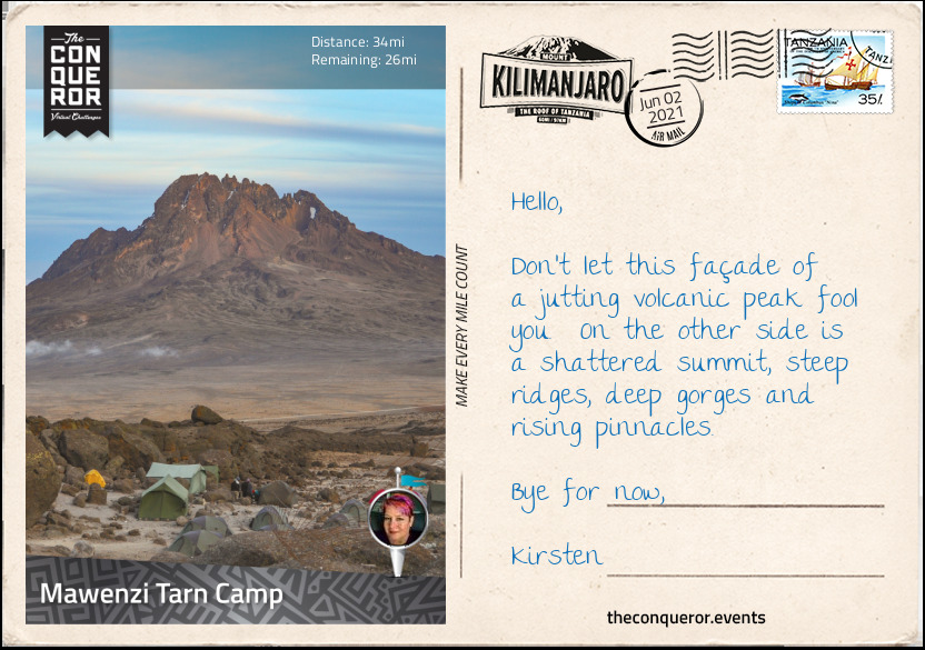
With under two miles (3km) left the trail ascended steadily reaching a lake at the foot of the rising steep ridges of Mawenzi, the second highest volcano southeast of Kibo. Mawenzi along with Kibo began erupting about a million years ago. The two peaks were separated by the Saddle Plateau. From the western side Mawenzi looked like a single jagged rock jutting from the saddle which was vastly different from Kibo’s gentler-looking and trekkable slopes. This western side of Mawenzi was the highest point reaching 16,893 ft (5,149 m). It was named Hans Meyer Peak, after the first person to summit Kili.
However, Mawenzi was actually a horseshoe shape with three steep ridges and two deep gorges in between them. With such steep ridges, Mawenzi can’t hold any glaciers leaving no permanent snow, unlike Kibo with its permanent glaciers and year-round snow.
Although Hans Meyer attempted to climb the Mawenzi peak in 1889 after he summitted Kibo, he did not succeed due to illness. The first successful summit was made by two German climbers in 1912. Because Mawenzi is a technical and hazardous climb the peak was closed to climbers for more than a decade. Although reopened in 2017 climbers and guides must be experienced rock climbers and can only proceed two at a time.
Leaving the peaks of Mawenzi to the experts, I will gladly admire its jagged appearance from the lakeside camp. With a hot cuppa in hand and a load off my feet I reflected on my journey so far and what is yet to come.
Heading south across the saddle that connects Kibo and Mawenzi, I descended about 1312ft (400m) till I reached Maua Route. Taking a right turn at the junction, I joined the Horombo-Barafu Trail on an upward westerly approach. Skirting one of Kibo’s lower ridges the elevation gained from the junction was 3280ft (1000m) slowly inching toward the top of the ridge. As the local guides say in Swahili “pole pole” meaning “slowly, slowly”.
At the top I continued across the edge of the ridge to Barafu Camp to rest, refuel and rehydrate. It was not unusual to drink 4-5 litres of water per day. Typically I had 2-3 litres during the trekking phase, a litre before dinner and another before I went to sleep. Staying well hydrated helped with acclimatisation and altitude sickness.
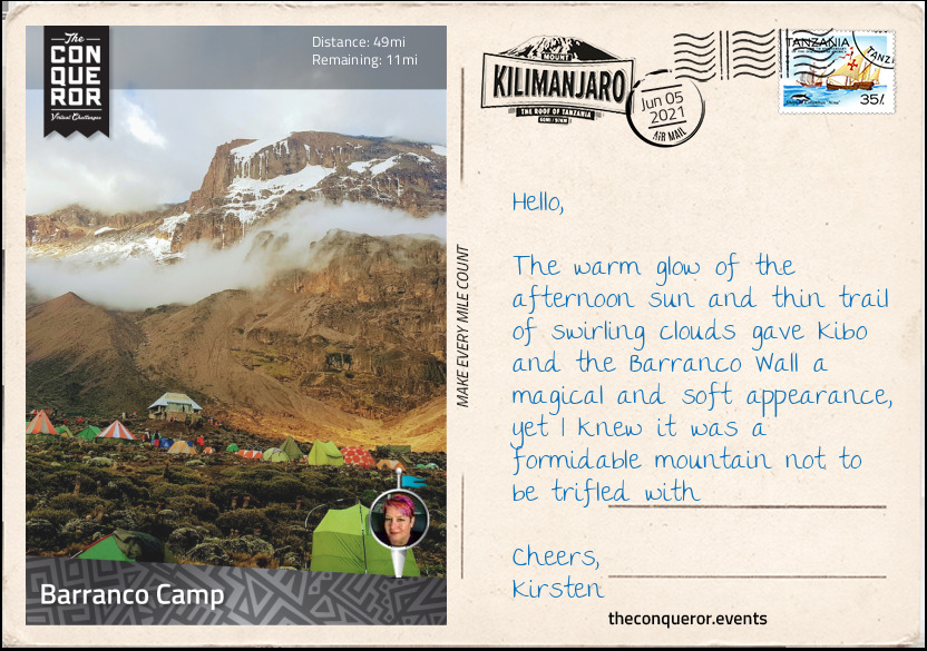
I traversed southwest for the next 2mi (3.2km) to Karanga Camp and then a northwest climb to Barranco Wall. Now for anyone on the southern or western trails up to Kibo would have had to contend with a 843ft (257m) scramble up this sheer cliff face making it even more challenging to those afraid of heights. Barranco Wall was vastly different to the mostly gentle slopes of Kibo. The Wall was the result of a huge landslide that occurred about 100,000 years ago. Kibo was originally taller, almost 19,500ft (5944m) when portions of its summit pyramid broke away, slid down the southern face and created Barranco Wall. Although not a technical climb, the scrambling needed all four limbs to climb up. Because the path was narrow and it cut back and forth along the rock face, solid placement of hands and legs throughout the climb was necessary.
Given that I took the circumnavigational route, I didn’t need to undertake this climb and was pleased to take in the views from the top of the Barranco Valley below. However, I did have to descend it in order to get to Barranco Camp for the night. An extra workout for my quads, hamstrings and knees.
Located in the Barranco Valley the campsite was amidst a grove of giant dendrosenecios. Looking at them in abundance, I couldn’t help but see them as these small compact hanging gardens atop tall thick trunks of trees.
Wondering into the mess tent, I eyed the hearty beef ghoulash with vegetables and the fresh bread but not before I indulged in a comforting potato and leek soup. The banana fritters for dessert were also well received along with my usual hot cuppa.
This was the final stage of my journey. Having left Barranco camp, I carried on westwards in a zigzag fashion, descending 984ft (300m) until I reached the Machame Trail junction at 12,139ft (3700m). Turning right onto the trail I knew this was the final ascent but also where my breathing would be challenged the most.
Trekking through alpine desert, the sun was strong and glaring and the temperature cold and dry. As I gained more altitude, the air thinned out further. It became very important to set the right pace to manage my heart rate and oxygen intake. Move too fast and I would get dizzy, lose energy and fatigue the muscles. Move too slowly, I’d fall behind and potentially run out of time to summit.
With a slow and steady approach, I arrived at Lava Tower. At 300ft (91m) tall, Lava Tower is a volcanic plug. During one of Kili’s past volcanic explosions lava erupted out of a vent, cooled then hardened like a plug. Luckily Kili is no longer active because this kind of plug could build pressure below the surface that could potentially erupt violently.
There was a time when the tower was climbable but due to safety concerns it is now prohibited. Those who had the chance to climb it in the past said the views of Uhuru Peak were just amazing. At the base of the Tower is the Lava Tower Camp. Set a little lower, the camp provides an opportunity to rest and recover from the lengthy ascending hike and effects of high altitude.
From Lava Tower there are two ways to climb up to the Summit. Either via a descent to Barranco Camp, before an ascent to Stella Peak and then Uhuru Peak or the treacherous Western Breach Wall.
I opted for the latter. Although the Western Breach Wall is known as one of the most hazardous routes to the summit, I chose it for several reasons. One, it was the shortest route to the top. Summit is done during the day rather than overnight and no traffic jam at the top. I was also able to sleep in a crater and explore glaciers.
Now the downside is that the Breach Wall, which is a gap formed by lava flow, is made up of soft loose rocks, the result of a rockslide. The top third of this wall is very nearly vertical and the rocks here are often held together by the glaciers above. When the glaciers melt and retreat the previously bound rocks are released and tumble down the mountain. Beneath the wall is a 30-45 degree mountainside which collects the fallen rocks from above and shoots them down a narrow chute to the bottom.
As such, the difficulty was not in the climb itself, even though there were many switchbacks to tackle, but the ever-present glaciers that gave no indication if they had retreated and loosened the rocks above. Although I had to trek through the dangerous chute, my time was kept to a minimum and as quickly as was possible at that altitude I traversed to a safer pathway. It didn’t completely eliminate the danger but I was in a better position than if I had climbed directly through the ‘danger zone’.
When I reached the top the first thing I saw was the remnants of an ice cap that once used to cover the summit. Named Furtwängler Glacier, it seemed almost odd, looking at this large block of ice sitting atop very fine beach-like black sand. It was interesting to see the glacier and the sand cohabitating in the same space. Sadly in the last century almost 85% of the glacier had vanished. There was a time when Kili had 16 named glaciers and 3 icefields. In the last half a century at least four have vanished and at the rate they are melting it is predicted that in less than 50 years there will be no ice left on the mountain.
I skirted the crater rim to Crater Camp, elevation 18,865ft (5750m) to refuel and pondered that last stretch. I was a mere 475ft (145m) below the summit and about half a mile (800m) in terms of trekking distance. Of course without further ado, I pushed for that final ascent. Slow and steady over the next hour, focusing on just one step in front of the other, I wound my way up to the weathering summit sign and the spectacular views of Mount Meru, another volcanic mountain, to the southwest; Kibo’s three concentric craters; and the Northern Icefield beyond the crater.
In Swahili, Uhuru means Freedom. Here at the top of Africa, I felt free and unconstrained, just like this tall free-standing mountain called Kilimanjaro.