 My second virtual challenge is Mount Everest. I’m continuing the mountain theme from the Mount Fuji “climb”, and getting some shorter distance challenges under my belt before tackling the longer ones. This is only 64 kilometres, so it will help me build some momentum, and send a second shiny medal for my collections.
I’ve learned that the app will let me run challenges in parallel, but I want to experience them one at a time. Right now, I’m using just walking distances towards my total, but later on, I might consider splitting up my distances, so that the walking distance goes towards one challenge, and time on the elliptical machine goes towards a second challenge. This still avoids me double-counting my effort, but would let me dedicate a challenge to a specific type of activity. It would be super cool if I could literally swim the English Channel challenge, but that would require that I get access to a pool. The condo pool is a better equipped for introducing toddlers to water than trying to actually swim, and the gyms are closed for now… but hopefully things will change once the COVID-19 vaccines are rolled out universally. Here’s hoping!
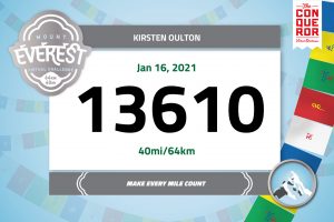
 As I finish each challenge, I’ll close out the day, and start the new challenge on the next day. I have my race bib for Everest, so I’m ready to go. My first day, I was so happy about closing out the Mount Fuji challenge that I combined two of my favourite walks back-to-back to get in some extra distance for the day.
If you want to try one of these virtual challenges, you can get 10% by following this link: theconqueror.events/r/KO3654.
Trips I’m not Making
I want to do a trip that worked through Nepal, Bhutan, and then maybe over to Mongolia. I could visit Taktsang Monastery, Bhutan’s famous “Tiger’s Nest” temple, steeped in legend and perched half a mile up on a sheer mountain cliff. Contrast that with exploring Nepal’s Chitwan National Park, home to Asian elephant, one-horned rhinoceros, sloth bear, spotted deer, golden jackal and more. Then wrap it all up with some time in Mongolia, horseback riding, flying a hunting eagle, and riding a camel. I have no idea how one packs a small suitcase for what would probably be three solid weeks in varying conditions, but it sure sounds like a challenge.
In the absence of exotic trips, I have street view maps as I begin the trek up Mount Everest. I am already well-positioned with two gigantic advantages: I am expecting better weather in Ontario than the summit promises and I am permitted to cover the distance over considerably less incline. Maybe I can string up some multi-coloured flags in the condo to give a bit of atmosphere…
Gyms are Closed: Need a Plan B
As a result of the latest round of COVID-19 lockdown rules, I find myself in a place where:
- Gyms are closed;
- The condo gym is closed for resident access; and
- It’s cold enough to not want to walk (my preferred activity) outside every day.
I needed a solution. I used to own a treadmill, but the condo forbids them as the noise carries from unit to unit. My brother suggested the fix: get an elliptical. If I picked the right unit, it would be very quiet. So, I put in an order (I am not nearly the first person to invest in exercise equipment after months of restrictions, so stock was low) and by the third week of January, I had a brand-new elliptical. Progress!
It is absolutely utterly silent. I’ve had Michael using it with the music on (Black Sabbath) and I could just barely hear it from the next room while I was working. Problem solved. Now I just need to build up the strength in my knee enough to use it for longer stretches. Right now, the cartilege sounds like a plastic accordion being played. If I keep at it long enough, it will get better.


Plan C
 Just as I start getting the hang of using the elliptical (my preference historically has been for a treadmill, and this caused my knees some distress at the beginning), something had to go kerflooey. Why? It’s never easy.
I’m having a great day. I get 60 minutes to go have fun, then 10 minutes on the elliptical… lather, rinse, repeat until I hit a personal best for the day. I look down at my wrist, and the Fitbit is black. I tap the screen. Nothing. I tap harder. Nothing. I plug the thing in to charge. Nothing. Tapping it and pressing the reset button. Tapping it by pounding it against the countertop, just in case my fingernail is no longer sufficient pressure. I’m calm, cool, and collected. Just like Captain Kirk dealing with Kahn Noonien Singh.
Hold on, I just did my best day ever, and neither the steps nor the activity minutes count? Are you kidding me? I go through a comedic series of support chats trying to:
- Troubleshoot the unit, but it’s dead, dead, dead;
- Get a discount on a replacement since mine is out of warranty period;
- Order the replacement only to have the computer swap shipping methods while the payment is going though to the slowest-possible option;
- Get help cancelling the order (since they can’t add on expedited shipping on a separate order);
- Try to re-order it, only the discount code doesn’t work because I’ve already used it; and
- Re-order the Fitbit and a new Aria scale to go with it so they can conspire wirelessly and mock me with their wee screens.
I’d like to claim that I’m a well-adjusted adult, but the evidence does not suggest it. I spent three days calculating my distance per day for the challenge manually, and am ever so happy to have my replacement Fitbit arrive so that I can now be pushed around by a watch.
February 5 is my Victory Day
I feel much better now, and logged the last bit of distance needed to complete the Everest challenge. Two challenges down already. I’m feeling great about that, and am ready to move on to the next challenge, which will be a longer distance.
So far, this motivational trick is working:
- I never fixed the integration between my Fitbit and the MyVirtualChallenge app on purpose. It turns out that if I write a great distance down at the end of the day, I feel great, and if I write a very short distance down, I feel compelled to redeem myself the next day. If the apps updated each other, I wouldn’t get the the same emotional boost (or kick in the pants);
- I am still enjoying getting the notice about each tree that they plant for each 20% of my goal. You can learn more about Eden Reforestation Projects by following that link. I’m getting a kick out of picturing my personal trees on a small scale, but I am definitely considering a larger reforestation venture at a later date as part of my work at The Pale Blue Dot Foundation; and
- While the elliptical isn’t racking up much distance each day (my tolerance for that motion is still less than just walking on the ground), it is starting to build strength in my weak joints and core, which is making the walks outside even easier.
2021 is at least trending in a positive direction so far. I’m enjoying the challenges, and wondering when the medal from the first one is going to turn up. Tomorrow, I am going to virtually visit the pyramids of Giza.
While you’re waiting for the next after-action report, you can take a look at the imaginary postcard collection from this challenge.
Postcard Collection
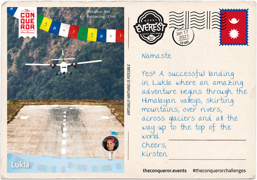
Flying into Kathmandu is a walk in the park when compared to Lukla. Dubbed as the most dangerous airport in the world, Lukla’s runway is a mere 1,729ft (527m) long, with mountainous terrain to the north and a steeply angled drop to the south. It is built on a 12% uphill gradient to help planes slow down. There are no go-around procedures if the planes miss their approach, as such only highly experienced pilots with short-takeoff-and-landing missions under their belt, experience in Nepal and ten flights in Lukla with a certified instructor, are permitted to land at the airport. In a nutshell if climbing Everest doesn’t cause prickles on the back of your neck, then a high intensity landing in Lukla certainly should.
In 2008, Lukla airport was renamed Tenzing-Hillary Airport in honour of Sir Edmund Hillary and Sherpa Tenzing Norgay, the first climbers to reach the summit of Everest. Hillary was instrumental in the construction of the airfield in Lukla, building an unsurfaced airstrip on a mountain shelf in 1964. It took 37 years to finally asphalt the runway.
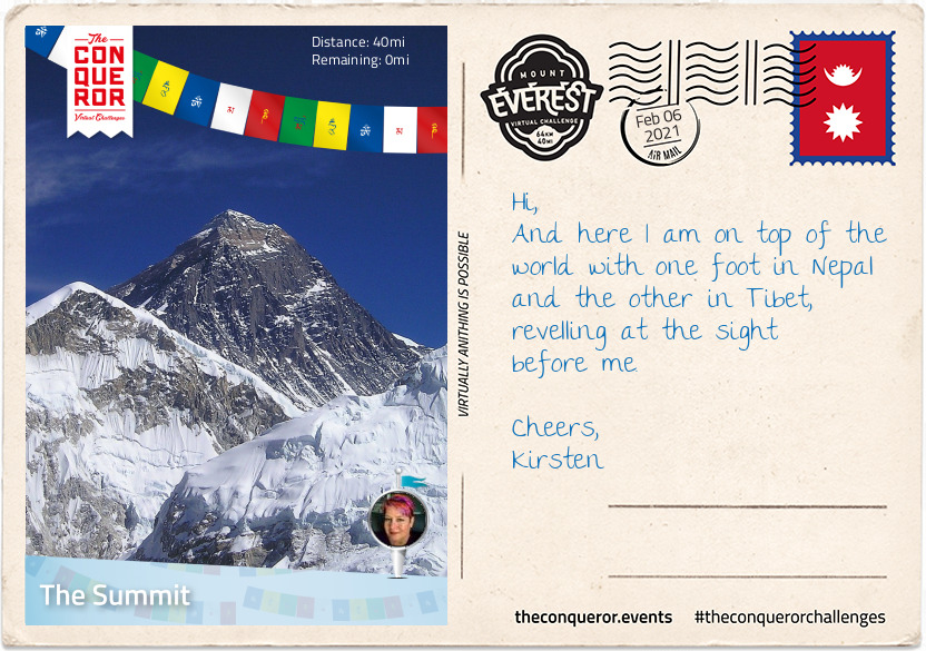
Home to 1200 people, the village sits at 9,383ft (2,860m) above sea level, nestled on a small plateau amongst the awe inspiring mountain peaks of the Himalayan Ranges. The nearly 40mi (64km) trek to Mount Everest, skirts steep mountainsides, through deep valleys and over alpine glaciers. The hike travels through small villages and teahouses, past prayer wheels and fluttering prayer flags to the memorial site honouring mountaineers and Sherpas who lost their lives climbing the mountain, continuing to Base Camp and then the final summit climb.
Leaving the viewing platform of the Lukla airport, I made my way through the centre of town on a narrow street that was sometimes cobbled and sometimes just compacted soil. Double-storey buildings lined the street filled with shops, teahouses and lodging services.
Shortly after leaving the village I passed through the National Luminary Pasan Lhamu Memorial Gate which was built to honour Pasan Lhamu, the first Sherpa woman to summit Everest in 1993. It is the gateway to the Khumbu Region that encompasses the Sagarmatha National Park and the Nepalese side of Mount Everest.
It was a gradual downhill hike, passing through a forest on narrow paths with the colossal mountainside ever present to my right. I continued on this downward hike, on a trail that wound itself up and down, passing through villages with teahouses until I reached Phakding, a small village that lies in the Dudh Kosi river valley. Here was the first of many suspension bridge crossings. The bridge, about 100ft (30m) above the river, stretched across what seemed to be an old landslide with large boulders and debris settling beside the river. As the bridge swayed and moved beneath my feet, I pondered about those whose fear of heights may find the crossing challenging. This isn’t the tallest suspension bridge on this trek, that is yet to come.
Finally reaching the small village of Benkar with its tin-roofed, brightly painted window frames, four-storey residences/storefronts, I settled into one of the teahouses for a meal. Known to aid with altitude adaptation I had garlic soup with Tibetan flat bread. Between the warmth of the soup and the crusty on the outside, fluffy on the inside bread, I filled my belly and finished with a Tibetan tea.
Rested and fed, I resumed my hike crossing another suspension bridge. Soon I reached the entrance to Sagarmatha National Park. A UNESCO listed site since 1976, the 1,148km² park is home to the Sherpa people, rare species like the snow leopard and several mountains including Mount Everest.
After obtaining the necessary permits to enter the park, I walked through the Jorsalle Entrance Gate, a concrete structure with Buddhist artwork on its interior walls to a set of steps that began a steep descent into a gorge, onto Jorsalle village, alongside the thundering Dhudh Kosi river and over two more suspension bridges.
However, what goes down, must come up and it wasn’t long before I engaged my hiking poles to start the steep ascent onto a woodland path until I reached a wide open low lying land beside the river filled with stones and boulders making trekking through it unstable and difficult.
But nothing prepared me for the next suspension bridge. Like all the others, Hillary Bridge was made of galvanized steel cables that’s connected to the grated deck by interlinked wire fence. An old version of the bridge was right beneath this one just hanging, blowing in the wind, no longer in use. At 410ft (125m) above the Dhudh Kosi river, this 459ft (140m) long bridge was exposed to the elements swaying laterally and vertically as the strong wind blew through the valley. It was a heart thumping, adrenaline spiking exercise that on this trek one could do without. I was grateful to reach solid ground.
Leaving Hillary Bridge behind at 9,514ft (2,900m) it was time for the next gripping ascent. Travelling uphill on single-lane switchbacks demanded patience, slowly shuffling along putting one step in front of the other, often needing to pull aside to let the steady stream of traffic pass me by. Mules, trekkers, porters and yaks were a common sight, breaking my already slow momentum. As I was gaining elevation, I could feel the change in the air, a shortness of breath, clearly indicating the change in altitude. I’d say more garlic soup was on the horizon.
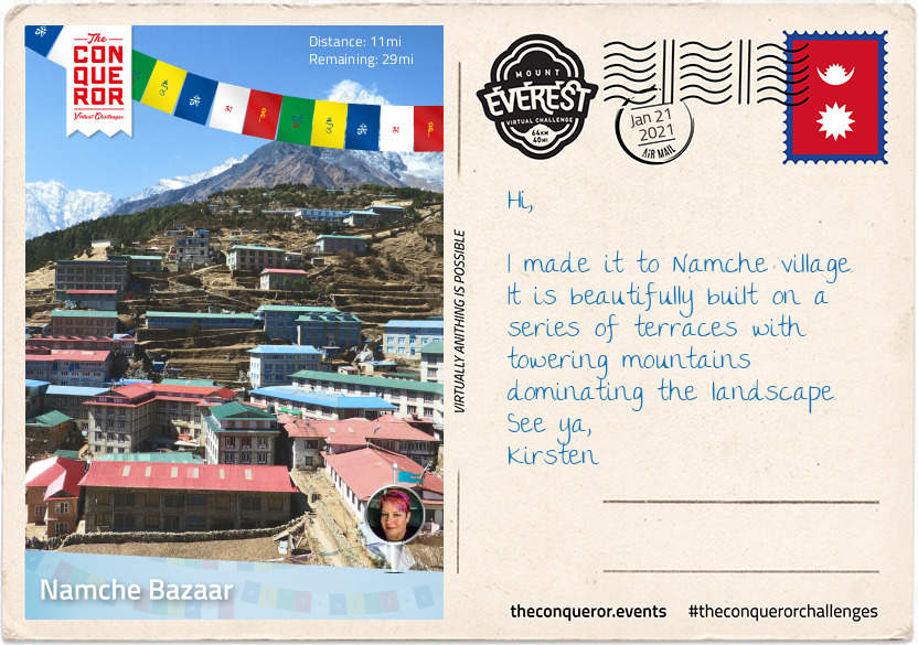
Two hours later I arrived in Namche Bazaar, the largest village in the region. Namche was located on a plateau, rising up the hillside at 11,285ft (3,440m). On either side of the village were the 19,800ft+ (6,000m+) peaks of Kongde Ri to the west and Thamserku to the east.
From single-storey to triple-storey buildings, a plethora of teahouses and lodges are readily available to service visitors and trekkers. Anyone who was up for a pint of Guinness or a shot of Jameson or Teeling Irish whiskey would find it in the centre of town at the remotest Irish Pub in the world.
Namche is a trading centre, altitude acclimatization stop, gateway to the upper Himalayan region and the final stop to purchase any gear needed for the upcoming trek to Everest.
Resting here overnight and taking the time to acclimatize, I stopped at a teahouse to enjoy the national dish of Dal Bhat Tarkari, a lentil soup with steamed rice, accompanied by seasonal vegetables and curried meat. It is a staple meal of the Sherpa people eaten once or twice a day as a perfect combination of protein and carbs for their physical workouts at high altitude.
Just slightly out of town up a hill is the Sagarmatha National Park Museum with a statue of Tenzing Norgay on the grounds. A worthy visit not just for the museum but also the amazing views of the surrounding peaks.
I spent a full day acclimatising with a nearby hike to Khumjung at an ascent of about 2,000ft (600m). Khumjung is a village known for the Edmund Hillary School which when built in 1961 only had one classroom but today teaches children up to grade 10. Then onto Khumjung Monastery to check-out the mysterious yeti scalp. The yeti is steeped in Himalayan folklore as a large monster which in western culture is known as the Abominable Snowman.
Before descending back to Namche, I grabbed a pastry and hot drink from the closest bakery and whilst standing outside absorbing the mountainous vista I watched the Sherpa women harvest the potato fields, a staple crop and one of the few that can be grown at such high altitude.
One more night of rest in Namche. The long, slow, steady climb awaits.
Leaving Namche Bazaar, the trail was wide and level following the curves of the Khumbu Yui Lha mountain. The mountain is 18,900ft (5,761m) above sea level and considered sacred by the Sherpa people. With the exception of one unsuccessful attempt in the 1980s, the mountain has never been climbed.
Winding my way up the trail, I could feel the climb in my legs as my muscles strained on sections of steep, stone steps then levelling out and just around the next bend it’d be another round of steep steps and on and on it went. Occasionally, I’d be rewarded with tiny peeks of Everest in the distance.
Suddenly, my trail began its descent to the valley floor and if I thought my muscles strained on the ascent, I now felt the strain on my knees during the descent. Reaching the village of Phungi Thenga, I traversed Dhudh Kosi river again and just as I made it into a gorge the trail took on another brutal ascent all the way to Tengboche. The highlight in the village is the Tengboche Monastery, a Tibetan Buddhist monastery for the Sherpa community. First built in 1916, the monastery has been destroyed and rebuilt a few times. Home to 60 monks, the prayer room is a kaleidoscope of colour with murals and paintings adorning the walls. A nunnery is a short trek away in Deboche.
Tengboche is beautifully located with its panoramic views of several peaks but the most outstanding was Ama Dablam and its imposing 22,349ft (6,812m) peak. Flanked by long ridges and a hanging glacier, it was first climbed in 1961 and it is the third most popular Himalayan peak for climbing.
The constant up and down trekking seemed a little self-defeating until I realised that since Lukla, I was an extra 3,280ft (1,000m) above sea level. I couldn’t ponder that for long as down into the valley I went again to cross Imja Khola river, a tributary of Dhudh Kosi.
Once I crossed the river, I left the woodland behind. The trail from here was in the open, no more trees in the way of my view presenting me with the enormity of this place. Up and down went the trail, yet progressively gaining elevation. The air had changed. A little thinner, a little colder, no trees to provide shelter from the wind.
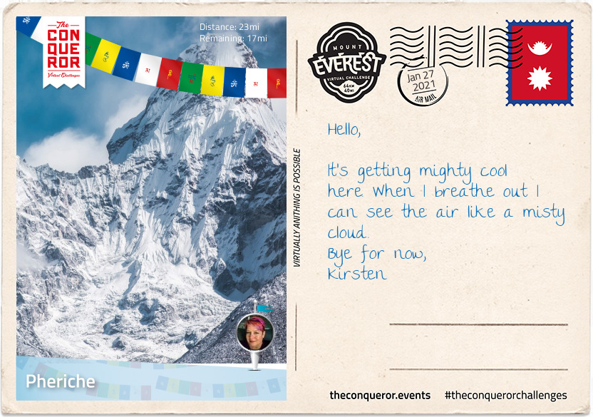
Eventually I reached the tiny village of Phiroche. It is located above the Tsola River at an altitude of 14,340ft (4,371m). It is a major stopping point for acclimatisation and also an evacuation point. The village has a hospital that runs during the climbing seasons and is operated by the Himalayan Rescue Association with Nepalis staff and volunteer doctors from the US, Europe, Canada and Australia.
Rather than sitting in a lodge, I dug out my gloves and beanie and very slowly over a period of about two hours, I hiked up to Nangkartshang peak (also referred to as the Dingboche Viewpoint) with an altitude of 16,676ft (5,083m). I was wonderfully rewarded at the top with a glorious view of several peaks such as Ama Dablam, Imja Tse, Tobuche and Lobuche and further afield even higher peaks Cho Oyu, Makalu, Lhotse and of course Everest.
As dusk was closing in I retired to my lodge for dinner. Looking for a warm and comforting dish, I settled on a hot noodle soup with pieces of meat and vegetables called Thukpa, accompanied by hot momos, steam filled dumplings.
With the Himalayas towering on either side of the trail, I trudged on and I say trudged because as you may well imagine fatigue, high altitude, low oxygen level and the constantly changing terrain was having an impact but as you may also imagine the desire to climb Everest was even greater and gave me the impetus to carry on.
The terrain morphed from tundra with low level shrubs to rocks and boulders. It was rugged, remote and massive. Rounding the bend at Dughla, a small hamlet and resting point, I was confronted by a pile of rising rubble where high up on the hill at 16,100ft (4,900m) is the terminus of the Khumbu Glacier, the highest glacier in the world. To the right I could see the glacial meltwater as it was making its way down the hill into the Lobujya River flowing southward as the Imja River and into the Dhudh Kosi.
The next hour’s climb was a steep 656ft (200m) trek to Chukpi Lhara. Set atop a large plateau, Chukpi Lhara is Everest’s memorial ground. Monuments made of stone or cement, some covered in prayer flags were built to honour climbers and Sherpas who lost their lives on Everest. It was a sobering and reflective moment.
Located at the foot of the Khumbu Glacier to the east and the soaring peak of Mount Lobuche East to the west sits the seasonally busy village of Lobuche. The village is the second-last stop for overnight lodging before base camp. Mount Lobuche has two peaks and is differentiated by calling it East and West. Permits are required to climb the mountain with East (20,075ft/6,119m) being classed as a trekking peak, whereas West (20,160ft/6,145m) being classed as an expedition peak. The two peaks are connected by a long and deeply notched ridge with sheer drops on either side making the West peak inaccessible from the East but it can be climbed via the southern shoulder.
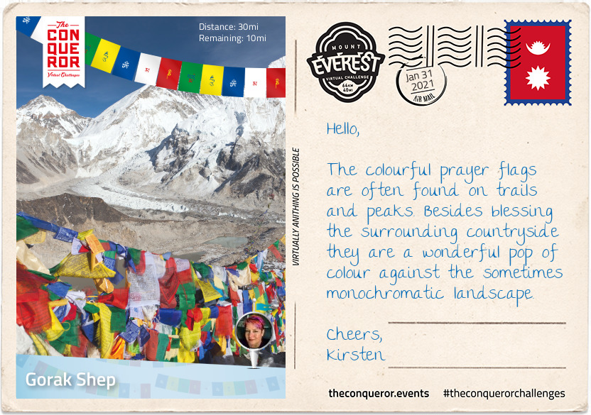
I didn’t stop in Lobuche, I pressed on to Gorak Shep the absolutely last place to stay in a lodging. The village was buzzing with trekkers and climbers either coming or going. At an elevation of 16,942ft (5,164m), Gorak Shep was located at the base of Mount Pumo Ri on the edge of a frozen lakebed covered with sand with Khumbu Glacier to the east and Changri Shar Glacier to the west.
The village was completely barren and devoid of vegetation but the peaks were ever-present from every angle. The summit of Kala Patthar on the south ridge of Pumo Ri was a major landmark for any trekker who wanted a clear view of Everest and Nuptse’s peaks. Because of Everest’s structure view of its summit from base camp is blocked by Nuptse. Climbing Kala Patthar was another great way to acclimatise. With an elevation gain of 1,270ft (390m) it was a short-two hour return trip. After a hearty lunch of curry potato and paratha bread for dipping, I was ready for the last trek of the day.
Starting out with an easy hike, I nearly missed the iconic yellow and red sign against a huge boulder simply stating “Way to Everest B.C.” with a big red arrow beneath the words pointing towards base camp. At least I was certain I was on the right path.
After what felt like hours of trekking, the treacherous Khumbu Icefall loomed into view spilling its way down the valley between Everest and Nuptse. Khumbu Icefall sits at the head of Khumbu Glacier, a constantly moving sheet of compacted ice. As the glacier makes its way down the valley it fractures, creating deep crevasses that are always in motion and large towers of ice called seracs that are known to suddenly collapse.
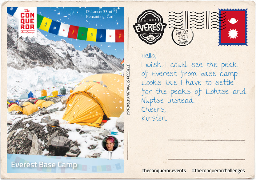
Making the final ascent I arrived at the cairn adorned in prayer flags with its rudimentary sign signalling that I have arrived at Everest Base Camp (17,477ft/5,327m). It was located on a scree-covered section (loose broken stones) at the foot of Khumbu Icefall. I settled into one of the yellow tents and mentally prepared for the high altitude acclimatisation process I would begin to endure.
As sea-level dwellers our bodies are not designed to live at high altitude but we are certainly capable of adapting to it through appropriate acclimatisation. The higher we go, our bodies go through physiological changes by producing more red blood cells in order to carry more oxygen to our muscles and organs whilst combating the thinner air.
The acclimatisation process on Everest is lengthy taking up to a month and done by exposing the body to higher and higher altitude then descending to sleep, recover and overcome any signs of acute mountain sickness due to sudden changes in altitude.
High altitude sickness can affect any person regardless of fitness or age. Ignored or left untreated altitude sickness can have serious consequences including fatality by developing either into cerebral oedema or pulmonary oedema which is fluid build-up in the brain or lungs. Some of the immediate ways to treat altitude sickness is by taking specific medication, supplemental oxygen and/or descending.
During that month I climbed and returned to base camp three times with each climb going higher. It looked something like this:
- Base camp to icefall, return to base camp. Have a day of rest.
- Base camp across icefall to Camp 1 and stay; then Camp 2 return to Camp 1 for sleep; then Lohtse Face return to Camp 2 for sleep; and descend back to base camp. Have four days of rest.
- Climb to Camp 1 and stay; then Camp 2 and rest the next day; then Camp 3 return to sleep at Camp 2; and descend back to base camp. Have five days of rest and wait for the right weather to summit.
The anticipation was over and the much awaited good-weather window presented itself for the final part of the expedition: Summitting Everest.
Starting in the wee hours of the morning, geared up and harness on I negotiated my way through the camp under the light of my headlamp to Crampon Point and attached my crampons to my boots.
Staring out at Khumbu Icefall with a good dose of mixed emotions I began the perilous yet now more familiar climb across. Crevasses were crossed on horizontal ladders and towering ice blocks on vertical ones. Some crevasses were so wide that more than one ladder had to be tied together to bridge the gap. For safety I was clipped into fixed lines. If I was to lose my footing on the ladders and fall the fixed lines would help break my fall. Climbs in some areas fluctuated between 20 to 60 degree angles but there was no time to dwell as the ongoing shifting and settling of the glacier and icefall was a constant reminder how unsafe the area was and moving quickly was necessary.
Several hours passed crossing the icefall till I made it to a large flat expanse of snow with more ladders to climb all the way to Camp 1. Situated at 19,390ft (5,910m), Camp 1 was in the middle of the Western Cwm (Cwm is Welsh for valley), a broad and flat glacial valley. From here I could see the Pumo Ri Mountain to the west and Lhotse Face straight up the valley. I then climbed on to Camp 2 about 1.74mi (2.8km) further up from Camp 1. Located at the base of a gully on scree, Camp 2 was well provisioned and is often considered as Advanced Base Camp. I stopped for a day of rest.
Early next morning I began making my way across the Western Cwm to the base of Lhotse Face where I had to cross a short ladder over a bergschrund (a deep crevasse where the steep slope meets the glacier). Lhotse Face is a 3,690ft (1,125m) glacial wall of blue ice. Sections of Lhotse Face average 40 degrees incline thereby needing to kick my crampon points into the ice to secure my footing. Throughout this climb I was clipped into a fixed line which was attached to the face with ice screws and anchors. I could feel the altitude change, my breathing labouring as I slowly and steadily climbed my way into Camp 3. I was now at 24,015ft (7,320m) gaining an elevation of 6,538ft (1,993m) from base camp. There were several camping spots here, essentially wherever one could find a flat spot to pitch a tent. I remained fixed to my safety line. The sun was up bestowing me with glorious views of the valley below, the peak of Pumo Ri and the others beyond.
On the border of Nepal and Tibet (autonomous region of China), standing proudly at 29,032ft (8,848m) is Mount Everest, the tallest mountain in the world and crown jewel of the Himalayas. First summitted in 1953 by Sir Edmund Hillary of New Zealand and Sherpa Tenzing Norgay, Everest has since been summitted by over 5,700 people a staggering 10,000+ times. Of course like any high risk activity, accidents and deaths do occur and in the last century just over 300 people have lost their lives on Everest. Although Everest has 17 different routes to the summit, only two of them are primarily used: the North Ridge route from Tibet and Southeast Ridge from Nepal.
As the air continued to thin the remainder of the climb was done with supplemental oxygen, using a full face mask with a rubber tube that connected my mask to a metal cylinder that held the oxygen tucked inside my backpack. The cylinder had a regulator on top that controlled the flow of oxygen.
Heading out from Camp 3 at sunrise I made my way up steep terrain for about 500ft (150m), traversed to a strip of limestone known as Yellow Band, across a stratified (layered) rock-ledge and up a 200ft (60m) at 40 degree angle stepped rock cresting the Geneva Spur. Following a rocky path I arrived at South Col (Camp 4) and had my first view of Everest’s peak. The true summit wasn’t visible from here but I could see most of the route to the South Summit (the secondary summit).
South Col was a waypoint for the final stretch at an elevation of 26,000ft (7,925m). Here I ate what little I could ingest as my appetite waned (a common problem at high altitude as the body no longer metabolises food efficiently), rested and waited for the night to roll in. Most climbers will depart for the summit between 10pm and 2am and take anywhere between 8 to 12 hours to reach the summit.
Wanting to catch the sunrise just before 5am, I checked my gear, put my headlamp on and headed across a broad plateau before ascending the steep 40 degree Triangular Face to the Balcony, a resting platform at 27,500ft (8,380m). Many of the early climbing teams including Edmund Hillary, put in a higher camp here in order to give them a shorter time to the summit and more time to climb in the warmth of the sun. Nowadays it’s rarely used. I took the opportunity to change my oxygen bottle, rest, eat and hydrate.
Once I crossed over 26,246ft (8,000m), I was technically in what is known as the “Death Zone”, where the oxygen is so thin that it is unable to sustain human life. Up here the oxygen level is 33% of what is available at sea level. At this altitude the body uses up its oxygen stores faster than it can replenish and without supplemental oxygen the body deteriorates and shuts down. That is not to say that experienced climbers haven’t succeeded in reaching the summit without supplemental oxygen. In 1978, Reinhold Messner and Peter Habeler were the first climbers to summit without bottled oxygen. A mere 0.02% have succeeded to summit without oxygen since.
From the Balcony the route took a slight left on gentle terrain till the route moved north and I was met with a 200ft (60m) slab of steep rock and snow terrain. Clipped into my fixed line, I pulled myself up using a jumar (ascending device) and in some exceptional steep sections my crampon points were precariously placed on jutting rock, strongly hoping they wouldn’t slip. It didn’t end here. When I made it above the slab, I was met with an even steeper section with a 60 degrees incline but thankfully it was shorter at around 100ft (30m).
Cresting the South Summit, I stopped for a short hydration break and a snack. From here the next section was a 20ft (6m) vertical drop, followed by the Cornice Traverse, a knife edge-like ridge-crossing to what was once known as Hillary Step. The Step was a nearly vertical rock face of 39ft (12m) and a technically difficult climb but it was destroyed when the region was struck by an earthquake in 2015. What was left were snow steps at 45 degree angles. It was debatable whether this was an easier way to climb but the real loss was the “Hillary Step monument”, a testament to Hillary and Tenzing’s success as the first summiteers.
With the end in sight, it took a further 20minutes to reach the pinnacle of the world. Adorned in prayer flags the summit at 29,032ft (8,848m) was a breathtaking 360 degree view of mountain peaks, glaciers and valleys. I watched the sun rise, casting an orange-red hue across the diminishing night sky as I reflected at the magnitude of this journey.
In Edmund Hillary’s words: “It is not the mountain we conquer but ourselves.”
To bring this journey into visual perspective you may wish to watch this YouTube video illustrating the climb from base camp to summit in 3D using GoogleEarth: Everest Base Camp to Summit in 3D.